


Snowy Owl eBird Map 12-08-15
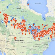
I heard that some people around these parts like Snowy Owls, huh? Where are the birds now? Well, here is where they were from October 1 through this morning on December 8 thanks to eBird, with all of the orange markers being sightings in the last 30 days. From glancing through individual sightings they seem to be hugging the coastlines so far from the Great Lakes to the Atlantic, and while this is typical, it seems to be the case a little more than usual. Snowys are in the fields, farms and grasslands more to the west in other areas of the upper Midwest and Great Plains. I would imagine that...
Read MoreMigration – August 12, 2015
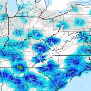
Here is the migration map – also known as the radar of the eastern continental United States – a few hours after sunset here on August 12, 2015. Avian targets, along with undoubtedly a few insects and bats, were mostly active in the southern regions where the wind is more consistently out of the north. For those of us in the Northeast we have a flow pushing birds to the Atlantic Coast, a typical occurrence for the fall. In another month the winds will be stronger and skies will be fuller. For now you can keep expecting to find birds like Bobolink, Orchard Oriole, Northern...
Read MoreHorned Spanworm Moth

Here is Nematocampa resistaria, the Horned Spanworm moth…does its appearance remind of you anything? For some reason all I could think of was an ancient and fraying map of sorts from another era, with intricate patterns and carefully crafted lines plotting out unique features all over those wings. Some of these spectacular little moths really make my imagination wander! When you were a child drawing all sorts of seemingly nonexistent creatures with your crayons you may have been closer to reality than you thought. Wrapping your mind around the thousands upon thousands of lifeforms on...
Read MoreRarities on the Wing
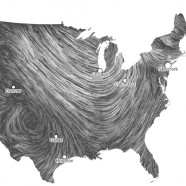
I took this screenshot late this morning via this always helpful and very cool wind map. They use surface wind data from the National Digital Forecast Database, updated hourly, to create this national flow of air. Even without it in motion you can see there is a huge trough in the east, with winds shooting down from the northwest until you get to about Chicago, at which point the bend brings them screaming out of the south and then the east higher into New England. All of this unsettled weather can easily push avian migrants out of their chosen path, bringing southern resident rarities up to...
Read MoreCrazy Climate Maps
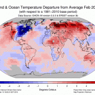
One benefit of the continual and seemingly never-ending cold and snowy winter (also known as spring now!) is that it provides us a tremendous opportunity to engage and educate people. The topic of our weather invariably comes up in every day life, especially now, and when someone complains about their heating bill or their aching back (thanks, shoveling!) you can mention to them that all of this may likely be due to our changing climate. The above graphic shows our globe and the general temperature percentile categories for meteorological winter, December through February, via NOAA’s...
Read More