


Record Shattering Cold & Historic Snow
To be entirely honest I meant to write this blog entry a couple of weeks ago. Yes, I have been busy during that time with meetings, gearing up for spring and summer projects, surveying, and much more. Nevertheless, I could not get myself too excited to write about the unbelievably and astonishingly historic cold we have had this winter, especially in February, or the feet of snow dumped on the region, rewriting more records for some locations. After feeling the first signs of spring in the past week I feel renewed, ready for the thaw and once again energized about our weather and climate....
Read MoreRecord February Cold
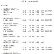
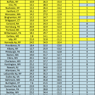
Look at some of these staggeringly low temperatures recorded overnight in western New York via the National Weather Service in Buffalo, New York! The Chautauqua County/Jamestown Airport ASOS recorded a low of -18, but a COOP observer on the outskirts of the city got it down to -30! Even Lake Erie didn’t help Dunkirk as it pushed down to -28! These are not wind chills – they are actual air temperatures. These are rather mind-blowing for mid-February, and once again it seems we have a year of extreme cold while the rest of the planet is warmer than usual. Is climate change going to...
Read MoreLake Effect Snow Band Eye?!
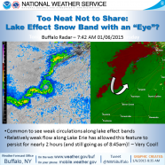
Here’s an amazing lake effect snow feature via US National Weather Service Buffalo NY from this morning – a band with an eye! It was not a snowcane but it did have circulation. Lake Erie certainly creates some unique and engrossing weather.
Read MoreLake effect snow on radar
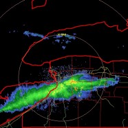
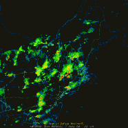
This heavy band of lake effect snow was ripping off of Lake Erie and belting Buffalo earlier this evening. It has since moved south, remaining mostly just north of Chautauqua County and hitting Erie County into Wyoming County. How much is falling? A midnight update from the National Weather Service said: * AT 1153 PM EST…NATIONAL WEATHER SERVICE DOPPLER RADAR INDICATED AN INTENSE LAKE EFFECT SNOW BAND CAPABLE OF PRODUCING SNOWFALL RATES OF 3 TO 4 INCHES PER HOUR…AND VISIBILITY OF A QUARTER OF A MILE OR LESS. THIS LAKE EFFECT SNOW BAND WAS ABOUT 10 TO 15 MILES WIDE WITH THE...
Read MoreSevere tornadic thunderstorm: six years later
The best – or worst, however you’d like to classify it – thunderstorm I have ever directly been impacted by and experienced fully happened six years ago today on August 7, 2008. As a weather nerd I will never forget that date. As a human being who values his life I will always remember what it was like to feel a tiny taste of the true power of the atmosphere. I was living in Stratford, Connecticut, a coastal town, and after a relatively typical warm, humid August day we entered the evening as I kept an eye on a large cell moving very slow to the east/southeast further...
Read More