Crazy Climate Maps
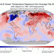
One benefit of the continual and seemingly never-ending cold and snowy winter (also known as spring now!) is that it provides us a tremendous opportunity to engage and educate people. The topic of our weather invariably comes up in every day life, especially now, and when someone complains about their heating bill or their aching back (thanks, shoveling!) you can mention to them that all of this may likely be due to our changing climate. The above graphic shows our globe and the general temperature percentile categories for meteorological winter, December through February, via NOAA’s...
Read MoreRecord Shattering Cold & Historic Snow
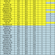
To be entirely honest I meant to write this blog entry a couple of weeks ago. Yes, I have been busy during that time with meetings, gearing up for spring and summer projects, surveying, and much more. Nevertheless, I could not get myself too excited to write about the unbelievably and astonishingly historic cold we have had this winter, especially in February, or the feet of snow dumped on the region, rewriting more records for some locations. After feeling the first signs of spring in the past week I feel renewed, ready for the thaw and once again energized about our weather and climate....
Read MoreBlizzard of 2015
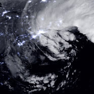
I love this very recent Throwback Thursday image from three days ago taken in space of the Blizzard of 2015 via NOAA/NASA. Having the state lines drawn in makes it very easy to identify locations based on night lights – for those in Chautauqua County you can see Jamestown and Dunkirk/Fredonia quite clearly along with other nearby cities. Isn’t it astonishing how bright New York City is even while covered by clouds? While some of us were under the comma head and experiencing strong wind and snow (like me!) nearly everyone in the eastern half of the country and much of the Atlantic...
Read More


