


Cold front spurring migration
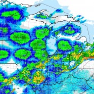
As thunderstorms are impacting us here in Chautauqua County on the edge of a strong cold front birds are in flight on the cooperative northerly flow in its wake. The roughly circular areas of green are all avian targets being picked up by radar stations behind it. They appear centered only because the EM pulse rises as it moves away in all directions from the radar and most birds are flying a few to several thousand feet up. The hole in the middle is the cone of silence as the pulse does not go straight up and is sent out at a low altitude. In reality birds are flying everywhere in those...
Read MoreSeptember fall migration
September fall migration is a go tonight! My old Connecticut home has been seeing a lot of great birds recently and they are experiencing very heavy migration right now as birds are pouring into the Atlantic Coast. Light southerlies are kicking up in the Midwest keeping things quieter there. Get outdoors and see what you can find tomorrow, from the forest to the shore.
Read MoreSevere tornadic thunderstorm: six years later
The best – or worst, however you’d like to classify it – thunderstorm I have ever directly been impacted by and experienced fully happened six years ago today on August 7, 2008. As a weather nerd I will never forget that date. As a human being who values his life I will always remember what it was like to feel a tiny taste of the true power of the atmosphere. I was living in Stratford, Connecticut, a coastal town, and after a relatively typical warm, humid August day we entered the evening as I kept an eye on a large cell moving very slow to the east/southeast further...
Read MoreHeavy rain at RTPI
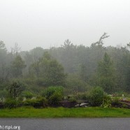
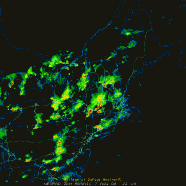
What’s that you say? More rain headed our way? It was earlier today with thunderstorms concentrating heavy rain directly over RTPI as this radar grab depicts and this photo displays. Fortunately it will indeed soon go away.
Read MoreSevere thunderstorm in Jamestown
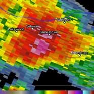
In the 5:0o PM hour today, August 2, 2014, we had a very severe thunderstorm in the Jamestown area despite it not being warned as one. Apart from nonstop cloud to ground lightning strikes and torrential rain dumping inches in a short period it had severe hail at least quarter-sized and perhaps nearing golf ball in some locations with vehicle damage reported, downed trees and lines, flooding and a host of other problems. Here was the cell on radar as it peaked regionally and close-up as it hammered Jamestown – pink and purple, over 70dBZ at times! We’ll show you some of hail and...
Read More