


Hurricane Matthew & Migration
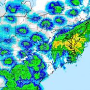
First of all, my thoughts are with all who were or are experiencing the very worst of Hurricane Matthew, a deadly tropical cyclone that has been ravaging areas from Haiti to Cuba, the Bahamas, and now the United States. I, like you undoubtedly, know people who took some of the heavy blows from the storm in Florida, Georgia, South Carolina and North Carolina. It proved to be a very difficult forecast which only exacerbated fears, and as heavy rain falls right now in the Mid-Atlantic and New England before the post-tropical cyclone heads out to sea instead of taking that long-discussed loop,...
Read MoreLeast Flycatcher (Empidonax minimus)
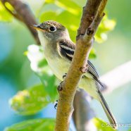
I love the Least Flycatcher’s scientific name (Empidonax minimus) as it is so very easy to understand. The tiniest of the empidonax flycatchers has a bold eye ring, and any yellow or green you seen on the feathers of this bird was a reflection of today’s warm morning light off the surrounding foliage. This was one of many cool migrants I enjoyed early this Friday, and the kind bird posed so well for me during an otherwise frustrating photography day. I wish you a wonderful Labor Day weekend of heading outdoors to see what you can find. It will also be a weekend of seeing what is...
Read MoreRadar Migration September 1, 2016
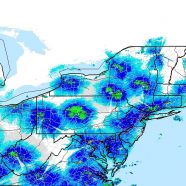
Happy September! Kick yours off with a great day of birding tomorrow and hopefully Saturday as the birds head out on the northerly flow behind the finally departed front. Once we get to Sunday the weather gets intriguing with Tropical Storm Hermine making a run to the Northeast and likely impacting conditions throughout the region. Remember that when looking at this radar capture the darker the blue, the more birds in the air. Green is even more intense and heavy migration. The birds appear to be basically centered around radar stations because the radar beam rises through the atmosphere as...
Read MoreRadar Migration October 1, 2015
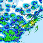
Here is an impressive view of the eastern United States just after midnight today, October 1, 2015. The precipitation we can see south of New England over the ocean and into the Mid-Atlantic and south is from a cold front that passed through yesterday and is now nearly stationary. It allowed migrant birds to take to the air on subsequent strong northerly winds. However, this front will creep back to the west, and we do not yet know what Hurricane Joaquin will do to the east coast. It will most likely thread the needle between an Atlantic high and a coastal low, moving into the Mid-Atlantic...
Read MoreLark Sparrow (Chondestes grammacus)
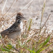
This Lark Sparrow (Chondestes grammacus) is the one rarity Twan and I enjoyed in the post-Irene week that was likely not brought in by the tropical cyclone. You can find them rarely in the east during the late summer and early fall while our friends to the west enjoy these beautiful sparrows all summer.
Read More